
This page demonstrates how to use Swiffle Grid with a Google Sheets data source.
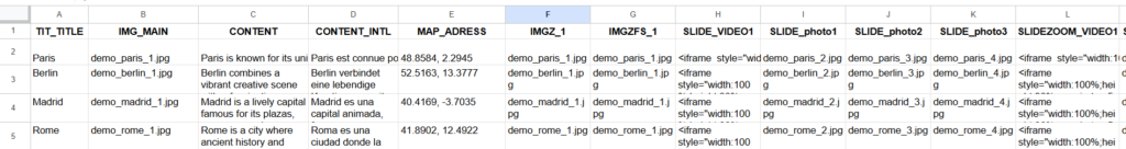
The connector reads the sheet and automatically interprets the columns based on their prefixes. The same naming rules apply to Google Sheets, CSV files, Excel files, and custom connectors that return structured arrays.
Column prefixes used by Swiffle Grid:
- TIT_ — Title (eg: TIT_CityName)
- IMG_ — Image, the first image becomes the main one on the front card (eg: IMG_Photo1)
- IMGZ_ — Zoomable image (eg: IMGZ_Detail1)
- IMGZFS_ — Full‑screen zoomable image in modal (eg: IMGZFS_Detail1)
- MAP_ — Coordinates used to generate an OpenStreetMap card (eg: MAP_Headquarters)
- NAV_ — URL opened when option is set on clicking the card front (eg: NAV_OfficialWebsite)
- SLIDE_ — Image or video embed added to the slide gallery (eg: SLIDE_Photo2)
- SLIDEZOOM_ — Zoomable image or video embed added to the zoom gallery (eg: SLIDEZOOM_Photo2)
- SLIDEFULL_ — Zoomable + full‑screen image (no video) (eg: SLIDEFULL_Photo2)
- HIDDEN_ — Used for sorting, filtering, notes, tags, or internal spreadsheet logic. Not displayed on the card. (eg: HIDDEN_Category)
- OTHER — Additional HTML or text content (eg: OTHER_Description)
⚠️ Important: Each column name must be unique. Duplicate column names may cause unexpected behavior when Swiffle Grid processes your data.
ℹ️ Info: If a NAV_URL column is defined, the back‑side content of the card (such as slide galleries or additional media) becomes unnecessary. The card will behave as a direct link, and users will not see the back‑side elements.
💡 Tip: If you need coordinates, ask your favorite “Copilote” — she usually finds them faster than any geocoding API.
Each row in the sheet becomes a card. Depending on the columns present, Swiffle Grid can automatically generate:
- a title
- a main image
- a map card from an address
- an “OPEN” button
- a slide gallery
- zoomable images
- custom HTML content
This makes it easy to build mixed layouts using simple spreadsheet data.